Chicago is not Part of the Bypassed East so here are some other facts from the Encyclopedia of Chicago (
http://encyclopedia.chicagohistory.org/pages/1260.html)
QUARRY NEAR JOLIET PENITENTIARY, N.D.
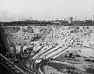 |
Metropolitan Chicago's topography is almost entirely a product of
glaciation. Only in scattered outcroppings is the underlying bedrock exposed in the form of low, isolated hills. The bedrock layers under the city of Chicago include massive reefs of limestone that are several hundred million years old, but they cannot be seen except in rock
quarriessuch as the giant pit along the
Des Plaines River at
McCook. At the other extreme are the human-created landforms of the Chicago region. Mostly the result of solid-waste dumping over the years, some of these mountains of trash (which now are grass-covered hills) rise 175 feet above the surrounding surface.
Chicago's flat topography is the result of its origin as a lake bottom. On at least three occasions between 14,500 and 4,000 years ago, glacial Lake Chicago, as this temporary enlargement of
Lake Michigan was known, rose and fell. The balance was determined by the size of the glacier that blocked drainage to the north and the depth of the Des Plaines River outlet through the bedrock layers near
Lemont. Glacial Lake Chicago was at its maximum extent about 12,500 years ago when it covered what is now the entire city of Chicago.
BEFORE HUMAN TRANSFORMATION (MAP)
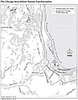 |
The various levels of glacial Lake Chicago are marked by beach features such as spits and bars that formed along the temporary lake's margins. On the north side are the
WilmetteSpit (Ridge Avenue, Wilmette); Rose Hill Spit (Ridge Avenue,
Evanston); and Graceland Spit (prominent near Graceland Cemetery at Clark and Montrose). On the
South Side, former beach lines are encountered along Ashland Avenue at 63rd (West Englewood) and 95th Streets (
Beverly) and in
Evergreen Park. Farther south and east the Toleston, Calumet, and Griffith Spits represent successively older beaches corresponding to successively higher lake levels that can be seen traveling south on Highway 41 from either
Gary or
Hammond.
Like present-day beaches, these ancient features consist of almost pure sand. In contrast are the glacial moraines that formed at the margins of the stagnant or retreating ice sheets and which consist of unsorted boulders, sand, clay, and pebbles. Prominent among them is the morainic ridge known as
Blue Island which was surrounded by the waters of glacial Lake Chicago. It extends from Dan Ryan Woods (87th and Western) nearly six miles south to the Calumet Sag Channel in Blue Island.
No comments:
Post a Comment